Mapping the Vineyard
This map series has been a decade-long project of mine. Aggregated from dozens of sources over many centuries, I sought to identify as many location names as possible, both formal and informal. No other print or digital map of Martha’s Vineyard has this density of names and history in one design. Please contact me if you wish to use in a publication. Prints can also be arranged. Frame-suitable giclées are printed on Epson archival matte paper. Turn-around is about three weeks.

Special thanks to A. Bowdoin Van Riper, Chris Baer, Alison Shaw, and the Martha's Vineyard Museum.
Series I Map: Martha’s Vineyard. 24"×38"
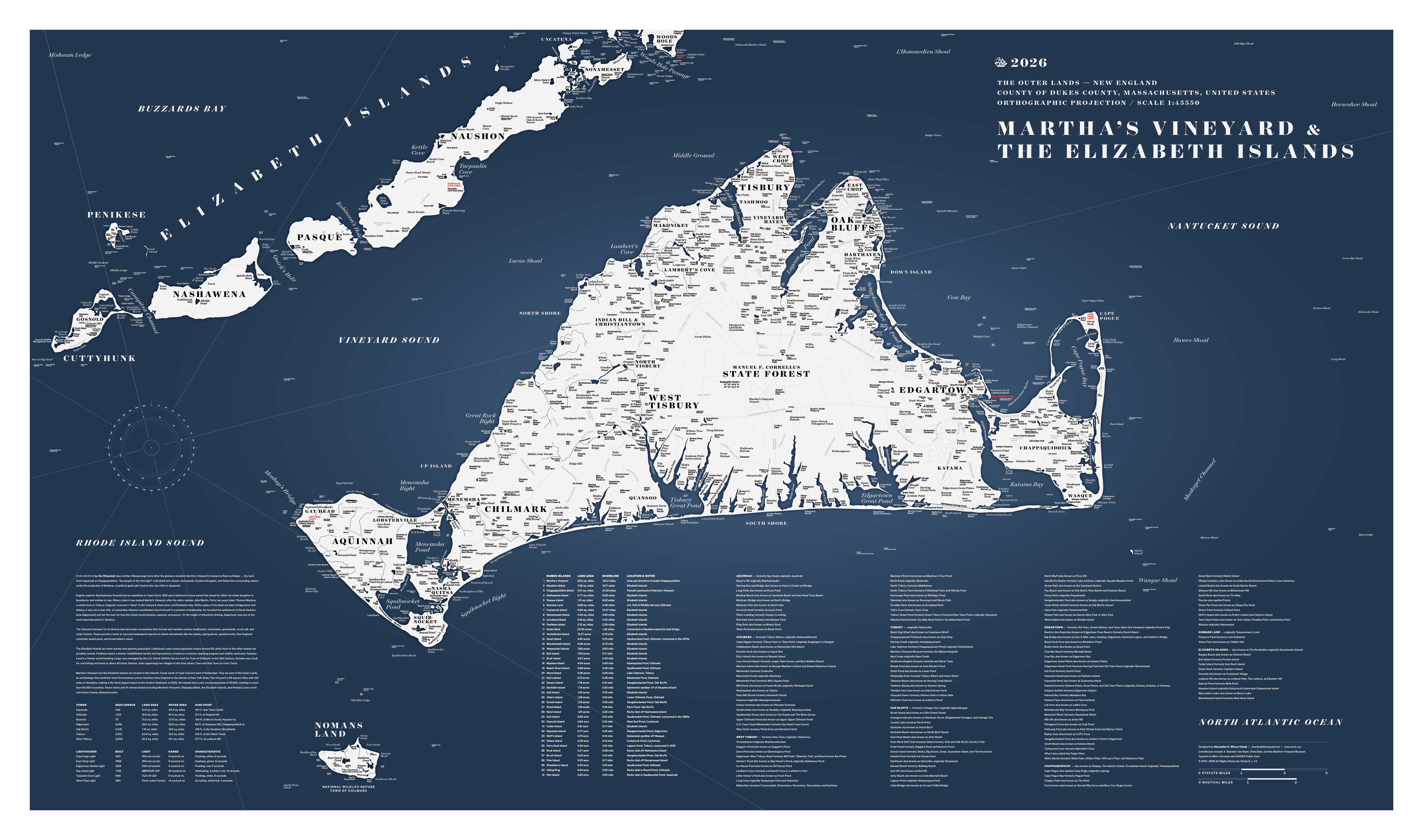
Series II Map: Dukes County, including Martha’s Vineyard, Nomans Land, and the Elizabeth Islands. 28"×47"
Mapping Martha’s Vineyard is a cartographer’s ideal project: it’s an island and its boundaries are utterly clear. The beaches, cliffs, bluffs, heads, and chops all bound the canvas in which to work. On the other hand, the Vineyard is 96 square miles, and within those beaches and bluffs is an immense number of locations.
To build on a tired comparison, the Vineyard is more dense with names than Nantucket: it has more ponds, streams, hills and ridges, towns, beaches, islands and even an “Island’s Island” (Chappaquiddick). While these islands are neatly contained, the Vineyard is just big enough to make this project more complex than it seemed at the outset.
When I began this work, I realized it could go in many different directions: a relief map that presents the range from the sand to the ridges, or a roadmap that brings forward the interesting names like Pancake Hollow and Road to the Gut. “Every map is the world seen through a different lens,” said Ira Glass, and my lens was to emphasize place names — as many as possible. With 96 square miles, that adds up to a lot of names, from the widely known to the historical. It also includes colloquial names that might only be recognizable by Islanders and Washashores — the ones you’ll never see on Google Maps.
An added degree of editorial sense is required with the dimension of time: when does an antiquated name warrant inclusion? The Great Plains in West Tisbury appears on many historical maps, but today it’s all wooded and all that remains is Great Plains Road. Pohogonot once had a small village, a school, and identity, but now the term appears mostly in the occasional real estate listing. Because the lens for this map has this historical dimension with a number of archaic names, it is different from your typical map. As a result, this map does not have a proper “date of situation.”
After seven years, I expanded Series I to include all of Dukes County, adding 19 more islands and a seventh town. In all the negative space, I added the shoals, holes, channels, and flats. In one area — the Woods Hole Passage — the named locations in the water outnumber those on land.
I was most surprised to learn that there was no clear, documented number of named islands in Dukes County (the County of Dukes County, that is). It’s 41. After adding this detail to the maps, I updated Wikipedia. Most of the islands are hard to step foot on; they are marshy, remote, privately owned, or under water at high-tide. A number have connected to nearby land over time, like Ferry Boat Island. Natick Island is not included in the list because it turned into Chappaquiddick’s Little Neck over 300 years ago. Chappaquiddick, of course, breaches and re-connects fairly often.
In addition to the 41 named islands,
- There are at least 71 named beaches and 72 named farms.
- There are at least 139 named ponds in Dukes County. Google Pond at Sweetened Water Farm was named after the owner’s cat.
- There are two “ghost towns,” though no structures remain: Gull Town and Jimmy Town on Nomans Land. Athernville, Davisville, Pohogonot, and Lobsterville are examples of former settlements that no longer exist, though Lobsterville is still widely used.
- There are two Gull Islands: one in Squibnocket Pond, the other between Penikese and Nashawena Islands. There are two Wood Islands, one in Farm Pond, the other in Rhoda’s Pond.
- Jaws Bridge in Edgartown has seven different names: Big Bridge, 2nd Bridge, Jumping Bridge, Anthier’s Bridge, American Legion Bridge, and 5-Mile Bridge.
- There are Herring Creeks, Herring Coves, and Herring Runs in every town except West Tisbury.
- There are two Little Necks, two Little Ponds, two Norton Points, two Big Fields, two Clam Points, two Flat Points, two Oak Grove Cemeteries, three Duck Ponds, four Lily Ponds, and four Long Points.
- There are six Bottoms: Deep, Frost, Quampache, Waldron’s, Willow Tree, and Woody.
- Swan Pond, Ben Luce Pond, and Lovers Rock are long gone, along with the Lucy Vincent Sentinel and the old chimney on Chappy.
- Farm Neck Golf Course is not really on the actual Neck named Farm.
- Some of my favorite places include Pancake Hollow, Painted House Rip, Chilhead, Gaymark, Blow Your Bugle Corner, Pizza Hill, Beetlebung Corner, Coca Cola Creek, Writer’s Row, Chip Chop, Road to the Gut, Old Man Ledge, Squash Meadow, and Gayloon.
- There are two “trap streets.” In Oak Bluffs, the meadow behind my childhood home never had a name, not even when I was growing up. It has a name now. A nearby marsh gained a name, too, but I can’t say which meadow or marsh because that would defeat the purpose.
- There are approximately 1,435 named locations accounted for on Series II, excluding alternative names included in the footnotes.
There are a number of locations that have appeared in texts that I can’t quite place:
- Israel’s Hollow
- Monaguoy Creek (Edgartown)
- Mud Creek (connecting Wilfreds Pond and Tashmoo?)
- Two ponds at North Neck, Chappaquiddick, that must have names
- "Hotel California" (a beach on Penikese Island?)
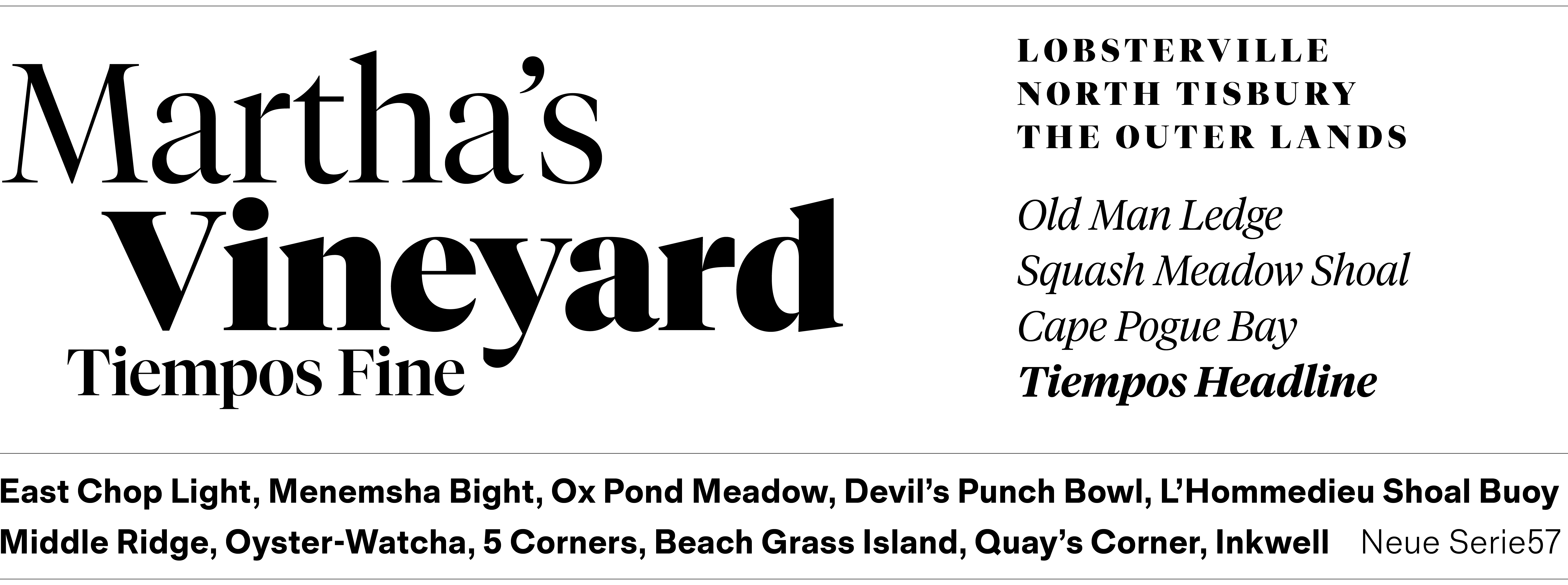
The maps were meticulously hand-drawn in Adobe Illustrator and typeset in Tiempos, a contemporary, refined serif, and Serie57, a hardworking sans-serif in the spirit of the early grotesques.
This project will never be complete. New names emerge and the shoreline shifts. Updates come often, so my maps all have a version number in the fine print.
Series III Map: Martha’s Vineyard Simplified. 12"×18"
Series IV Map: Martha’s Vineyard Simplified / Alt Colors. 11"×17"